       Region I
       Region II
       Region III
       Region IV
Wind speed and direction, water circulation, and transport in the
California Current vary within the four regions, on seasonal to decadal
time scales. Processes ranging from basin scale to local scale control
seasonal variations. In this section we present details about the
seasonal evolution of large scale structure in the CCS, for each of the
four regions identified in Figure 1.
Hickey (1979, 1989) and Huyer (1983) describe the flow field in Region I. After the onset of southward winds in the spring, upwelling raises isopycnals next to the coast, creating a density front and an equatorward jet over the shelf. The front and jet move farther offshore in response to stronger southward winds, and return onshore when the wind relaxes or reverses. A subsurface, poleward undercurrent is usually found over the shelf break. During summer, the southward jet moves farther offshore (up to 100 km), and poleward nearshore counter currents are often found. Storms begin in fall and the flow field becomes less organized. Eddies are found offshore in winter and the poleward Davidson Current develops over the shelf and slope.
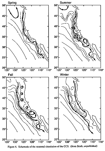
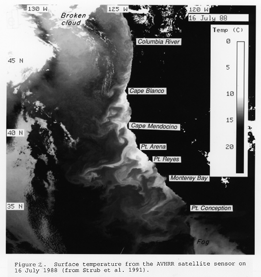
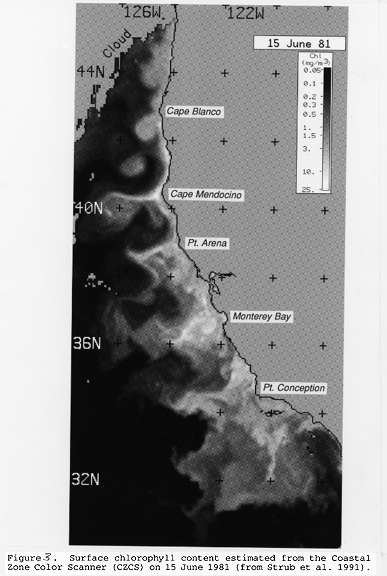
Coastal promontories in Region II cause changes in the local coastline orientation and topography which strongly affect the direction and intensity of coastal wind (Zemba and Friehe, 1987). Enhanced upwelling has been seen at Cape Mendocino (Largier et al. 1993), Point Arena (Kelly 1985), Point Ano Nuevo (Rosenfeld et al., in press) and Point Sur (Traganza et al. 1981). Suppressed upwelling has been observed both upwind of capes (e.g., north of Cape Mendocino, Largier et al. 1993) and downwind of capes (e.g., south of Point Ano Nuevo, in Northern Monterey Bay, Graham and Largier, submitted; Rosenfeld et al., in press.). Further, if there is a substantial area of weak winds downstream of a cape (i.e., in the lee of a cape), an upwelling shadow can be found (Graham et al. 1992). Moreover, in the lee of some capes, circulation patterns occur that are retentive. Energetic coastal jets and large offshore meanders also appear to be associated with some of these promontories, although it is not yet known whether the behavior of these mesoscale features is relatively more affected by changes in wind forcing, coastal geometry or bottom topography (Mooers and Robinson, 1984, Davis 1985, Kosro and Huyer 1986, Huyer and Kosro 1987, Brink and Cowles, 1991, and other papers in the same volume). Cape Blanco (43 deg N) is the most northern of these capes and the boundary between Region I and Region II. It has been hypothesized to be the location where the southward 'upwelling jet', found over the shelf or shelf break farther north, first separates from the shelf and begins its meandering path through Region II (Smith, 1992). In some locations (e.g. Pt. Arena) upwelled water advects up to 300-500 km offshore (Figures 2 and 3 show one such example) at high velocities (>50 cm s-1) in jets usually 20-50 km wide and 100-200 m deep (Brink and Cowles, 1991). Eddies are found in association with the surface jet, often cyclonic inshore and anticyclonic offshore of the jet, although eddies of both sign have been found on either side of the jet (Figure 4). Upwelling at the coast and within the eddies and meandering surface jet create the filaments seen in the satellite images of SST (Figure 2) and color (Figure 3).
When long-term averages are formed from the CalCOFI data, the core of the California Current off Region II lies about 100-200 km from the coast, with maximum equatorward velocities of less than 5-10 cm s-1 (Chelton, 1984). The offshore portion of southward flow is seen up to 1000 km offshore and extends deeper than 500 m, but the inshore section of the Current is limited to the upper 200 m over the continental slope (Hickey, 1979). It has been suggested that this average core is actually the temporally and spatially smoothed expression of the more intense, meandering alongshore jet that moves offshore between spring and fall (Huyer et al., 1991; Kosro et al., 1991; Strub et al., 1991; Smith, 1992).
The presence of a bathymetric ridge and islands causes considerable recirculation in the current pattern (Lynn and Simpson 1987). During most seasons, the mean current makes a sharp shoreward turn near the U.S. Mexican border (32 deg N), where it splits-one part turns poleward into the Bight while the other turns equatorward to flow into Region IV. During fall and winter months, the poleward branch joins the countercurrent and in summer months, it feeds a cyclonic gyre, circulating around the entire Bight, called the Southern California Eddy, which is centered over the ridge and islands. For a period in spring, the alongshore winds overpower these recirculation features and result in overall equatorward flow through the southern half of the Bight and along Baja California (Figure 4). The sharp shoreward turn in the California Current jet at times is accompanied by a modest offshore flow, producing a feature termed the Ensenada Front (Pelaez and McGowan, 1986; Thomas and Strub, 1990). This zonal feature acts as a biophysical division, which forms a faunal boundary (Brinton, 1967; Haury, 1984).
Plumes, jets and filaments that develop off northern and central California, feed into the California Current jet, which in turn enriches offshore regions off southern California. Pockets of upwelled water occur around the islands and within the Southern California Eddy. Although the above description of the flow patterns would imply mean flow out of the Santa Barbara Basin toward the west and into the main core of the California Current, a recent analysis of current meter data suggests there is some mean flow from the core of the California Current into the Santa Barbara basin just north of the islands (Auad, 1992). The amount of connection between the Santa Barbara basin and the main California Current is important, since there is a long paleo-sediment record in the Santa Barbara basin, raising the question of whether it represents the rest of the California Current or only very local conditions.
At most times of the year, an undercurrent flows poleward along the continental slope at levels between 75 and 250 meters. Part flows through the narrow opening into the Santa Barbara Channel and part passes along the northern islands and through openings in the bathymetric ridge. Evidence suggests that dynamic instabilities of the undercurrent are instrumental in generating mesoscale eddies which migrate offshore (Lynn and Simpson, 1990). An anticyclonic eddy is commonly found on the western edge of the California jet, near 33 deg N (Simpson et al., 1984).
CalCOFI has coarsely sampled the region off Baja California for many years. Monthly maps of surface and 200 db (200 m) dynamic height, relative to 500 db, have been published by several authors. Lynn and Simpson's (1987) maps for January, April, July and October indicate the strongest and most continuous equatorward surface flow next to the coast along Baja California in spring (see Figure 4). Flow is still fairly strongly equatorward but more convoluted in summer. It becomes weaker and even more convoluted in fall and winter, although still equatorward. This pattern is also shown by monthly maps of mean flow (Roesler and Chelton 1987). All of the analyses agree on the strongly coherent equatorward flow in spring, coincident with the maximum upwelling favorable winds. They also show the meander around Punta Eugenia for much of the year, as depicted in Figure 4. The less smoothed maps of Hickey (1979) and the individual surveys of Wyllie (1966) indicate a strong degree of mesoscale activity in Region IV, which has been confirmed from drifter releases in the northern part of the region (Poulain and Niiler, 1989). At approximately 200 m, a poleward undercurrent is found in the region within 100 km of the coast for much of the year, except in spring when the strong equatorward flow extends to this depth.
Using CalCOFI data, Huyer (1983) shows the mean SST fields for January and May. The May SST field shows strong cross-shelf gradients indicative of upwelling wherever the coast is parallel to the southward winds, i.e., everywhere from 25 deg N-32 deg N, except for the region just north of Punta Eugenia (28 deg -29 deg N). In contrast, SSTs in January show little evidence of upwelling, except perhaps weak upwelling between 30 deg N-32 deg N.
Studies off northern Baja California suggest that conditions are highly variable due to onshore movement of offshore eddies and wind-forced equatorward surface currents (Badan-Dangon et al. 1989)-e.g., responses similar to that observed over the shelf off northern California (Huyer and Kosro 1987). Farther south, at 27 deg N, Walsh et al. (1977) found that the oceanic response to variability in wind forcing is similar to the classic picture of upwelling off Oregon (Huyer 1983)-winds were upwelling favorable, isopycnals sloped upwards toward the coast, surface currents were to the south and offshore, flow at depth was onshore, and a poleward undercurrent.