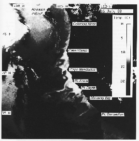
Figure 1. Surface temperature from the AVHRR satellite sensor on 16 July 1988 (from Strub et al. 1991). Click image for full-size image. Warning filesize = 1 Mbyte.
First, they are quantitatively significant both to human populations and in the global biogeochemical balance. Many of the world's most productive fisheries are found in and near coastal upwelling regions. Particularly for developing nations next to them, these ecosystems have great economic and sociologic importance, and their demonstrated and potential biotic variability is a major concern. In the United States, the California Current borders a concentrated and environmentally conscious human population. This group places considerable aesthetic and moral value on understanding and preserving the health of the local marine environment.
Second, eastern boundary currents are oceanographically and ecologically distinctive. The dominant patterns of life history and energy transfer contrast with those of continental shelf ecosystems. For example, pelagic fishes achieve high biomass levels compared to demersal fishes. Flow fields and their effects on organisms are also distinctive. Mean wind stress is typically alongshore with large temporal variability. Surface-layer flow usually diverges from the coast. This divergence is often particularly intense in the vicinity of major headlands. Continental shelves are usually narrow, and large offshore bathymetric features are rare. Although current patterns show strong temporal and spatial patchiness with suggestions of recurrent structure, the currents are much less strongly steered by underlying bathymetry than in coastal systems with wide continental shelves. In consequence, geographically fixed and predictable opportunities for horizontal recirculation and retention may be rare and widely spaced. For planktonic and larval organisms, advective input and loss rates are thought to be large.
Third, eastern boundary current systems are particularly appropriate for examining the higher-frequency components of global climate variability. Biological and physical responses to forcing at interannual (e.g., ENSO events) to decadal time scales are known to be very strong. The local response almost certainly involves a variety of proximate physical coupling mechanisms (e.g., altered wind speed and direction, pycnocline depth, alongshore and cross-shore advection, buoyancy inputs). Important lower-frequency components of biological variability (decades to centuries) are also clearly evident in reconstructions from historical and sedimentary data.
Fourth, many of the dominant species extend over a broad latitudinal range and are exposed to large differences in the intensity and timing of seasonal circulation patterns. Particularly for the nearshore benthic community, strong spatial gradients in probability of successful recruitment appear to be linked to differences in upwelling intensity. There is clear potential for within-region comparative studies of the controlling mechanisms.
The historical knowledge base for portions of the California Current is excellent. This is one of the few oceanographic regions for which there is a long time series of archived plankton and larval fish samples (the CalCOFI program, 1949-date). Commercial catch statistics are available from the early part of this century. Sediments from anoxic basins provide a longer record of changes in relative abundance for major fish species. There have also been a number of major shorter-term studies of the physical and biological oceanography of this region. Recent examples include the Coastal Ocean Dynamics Experiment (CODE), the Northern California Coastal Circulation Study (NCCCS), Fronts cruises, and the Ocean Prediction Through Observation, Modeling and Analysis (OPTOMA) and Coastal Transition Zone (CTZ) programs.
In the north, off Washington and northern Oregon, the picture of the flow field was developed in the 1970s (Hickey 1979,1989; Huyer 1983). After the onset of southward winds in spring, upwelling raises isopycnals next to the coast, creating a density front and equatorward jet over the shelf. The front and jet move farther offshore in response to stronger southward winds, and return onshore when the wind relaxes or reverses. A subsurface, poleward undercurrent is usually found over the shelf break. During summer, the southward jet moves farther offshore (up to 100 km), and poleward nearshore countercurrents are often found.
Storms begin in fall, bringing northward winds that are strongest in this northern region. With their onset, the flow field becomes less organized, eddies are found offshore, and the northward Davidson Current develops over the shelf and slope. In the historical satellite data, filaments extending several hundred kilometers off this northwest region are found most often in fall. In both the upwelling and the storm-driven regimes, velocities in the jets and eddies can be energetic, reaching speeds greater than 0.5 m/s. The Columbia River creates a freshwater plume in the upper 5-30 m; the plume extends several hundred kilometers offshore to the southwest in summer and to the northwest in winter.
The flow field in the middle region between 35°N and 43°N has been the subject of intense study in the 1980s, with the most effort concentrated in the region between 37°N and 41°N. This is the location of the strongest southward summer winds (Nelson 1977; Strub et al. 1987). Field data from the CODE, OPTOMA, and CTZ programs show a strong seasonal cycle in the surface currents (Strub et al. 1991), with jets and eddies that are less energetic in winter than in summer, when velocities of over 1.0 m/s are observed (Kosro et al. 1991; Huyer et al. 1991) . Although neither the complete velocity structure nor the continuous evolution of even part of the structure has been directly observed, the evidence suggests that a nearshore jet develops after the onset of persistent southward winds in spring (perhaps similar to the jet and upwelling front found north of 43°N) and quickly moves offshore, developing meanders that extend 300 km or more from the coast. A poleward undercurrent is found over the shelf break and slope. Eddies are also found in association with the surface jet, often cyclonic inshore and anticyclonic offshore of the jet, although eddies of both signs have been observed both inshore and offshore of the jet. The eddies and meandering surface jet create the filaments seen in the satellite images of SST (Fig. 1) and color (Fig. 2). Multiple filaments are found in some cases, and the satellite imagery suggests that the flow field is more complex toward the south (34°N-39°N) than farther north. Poleward flow is often found next to the coast in late summer, especially during wind relaxations or reversals of the normally southward winds.
Figure 1. Surface temperature from the AVHRR satellite sensor on 16 July 1988 (from Strub et al. 1991). Click image for full-size image. Warning filesize = 1 Mbyte.
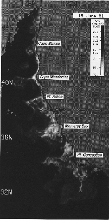
Figure 2. Surface chlorophyll content estimated from the Coastal Zone Color Scanner (CZCS) on 15 June 1981 (from Strub et al. 1991). Click image for full-size image. Warning filesize = 2 Mbytes.
In the fall and winter, storms with northward winds affect the region, especially in the north. The northward Davidson Current develops next to the coast at this time, as documented in CalCOFI data for the region south of 37°N (Chelton 1984; Lynn and Simpson 1987), although details of this evolving field are not well resolved by the coarse sampling.
An example of the large-scale flow structure found in mid-summer is shown in Fig. 3. The velocities in this figure were estimated by combining velocities derived from two types of satellite data. Most of the information comes from a sequence of six relatively clear AVHRR images of SST over a 30-hour period on 17-18 July 1988 (similar to the image in Fig. 1). Pairs of images, separated by 4-9 hours, were used to find velocities using the maximum cross-correlation (MCC) method of automated feature tracking (Emery et al. 1986). The average velocities at each location were found from the five fields formed from sequential pairs of images (Tokmakian et al. 1990). This average velocity field was then combined with cross-track geostrophic velocities from the ascending Geosat altimeter tracks from roughly the same period, using the method of objective analysis to fit a stream function to the data (Bretherton et al. 1976), to form the geostrophic velocities shown in the figure. A smoothing is inherent in the process, removing features with scales less than approximately 100 km.
Fig.3 shows a jet that appears near the coast in the north and separates from the coast in several locations. A meander off Cape Mendocino (40°N), with a cyclonic eddy inshore of the jet, similar to that shown by this figure (125.5°W), was sampled repeatedly in April-June 1987. The field sampling in 1988, at the time of this image sequence, covered the jet flowing to the southwest from Point Arena (39°N). This figure illustrates the highly advective nature of the California Current system, and is unlike the classic picture of the slow (0.1 m/s), gentle, mean flow in eastern boundary currents. An energetic jet (surface drifters moved at maximum velocities greater than 1.0m/s) flows continuously from 43°N to 35°N, extending hundreds of kilometers offshore and connecting to eddies that are up to 400-500 km offshore (129°W-130°W, 39°N-40°N) . Near-surface drifters that were deployed in the jet off Point Arena (39°N) in July 1988 showed that the cyclonic eddy at 37°N, 126°W-127°W and the anticyclonic eddy at 123°W-125°W, 35°N-36°N persisted for at least two months. Altimeter data indicate that the anticyclonic eddy farther offshore at 129°W-130°W, 39°N-40°N was present for at least two months prior to mid-July 1988 and may have propagated from a location closer to the coast, where an anticyclonic eddy appears in the altimeter field during February 1988.
The SST pattern from this July period in 1988 (Fig. l) resembles the patterns seen each July of 1981-87 (Strub et al. l991), indicating that this flow field is typical of summer, and suggesting that the location of specific features (the meander around Cape Mendocino, the jet off Point Arena, etc.) may be related to the capes or the subsurface topography, as suggested by laboratory and numerical models (Narimousa and Maxworthy 1989; Haidvogel et al. l991).
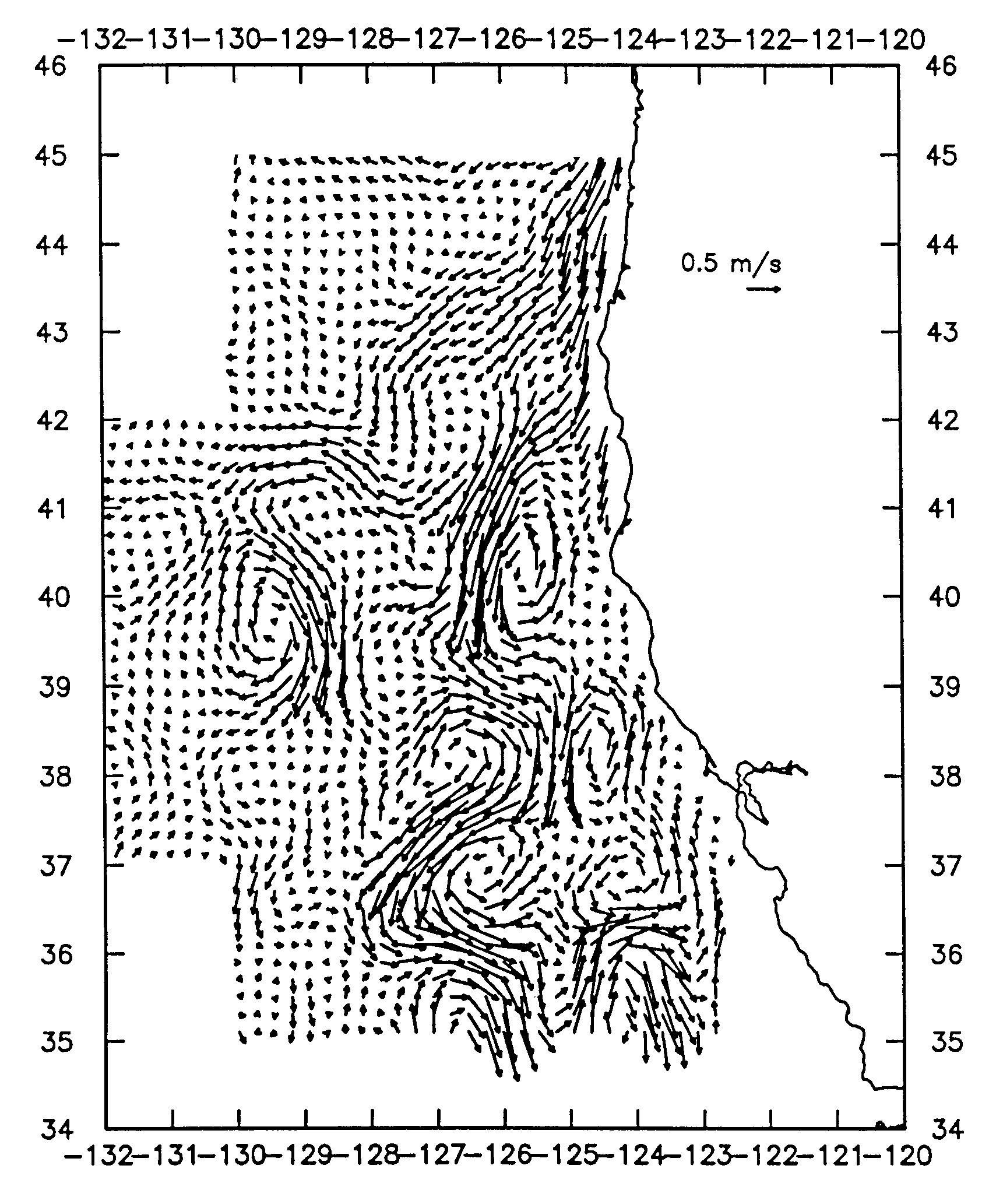
Figure 3. Surface velocity field estimated during mid July 1988 from a combination of altimeter cross-track geostrophic velocities and velocities estimated from a sequence of AVHRR images using automated feature-tracking (MCC).
The relation of the meandering jet to water mass and biological properties is discussed in a number of papers that analyze the 1987 and 1988 CTZ data sets (Brink and Cowles l991) . A low tongue of salinity is found on the offshore flank of the jet at 125°W-127°W, 37°N-38°N in Fig. 3, consistent with its connection to regions farther north (Huyer et al. l991), where the Columbia River plume creates a shallow lens of very fresh water north of Cape Blanco (43°N). Zooplankton distributions also show that the core of the jet carries species not found locally on either side of the jet (Mackas et al. l991) . Nutrients and chlorophyll concentrations are high, and SST is low inshore of the jet (Hood et al. 1990, 1991; Kosro et al. 1991; Huyer et al. 1991; Chavez et al. 1991), although patches of high chlorophyll and narrow filaments of high nutrients and low temperature are sometimes carried by the core of the jet (Hood et al. 1991; Strub et al. l991).
Within the jet, regions of both local upwelling and downwelling are found (Kadko et al. 1991; Washburn et al. 1991; Strub et al. l991; Chavez et al. l991). Idealized quasi-geostrophic numerical models of the jet predict enhanced upwelling in the onshore-flowing branch and enhanced downwelling in the offshore-flowing branch of the meanders (Allen et al. 1991). Primitive equation numerical models with more realistic topography show a more patchy distribution of upwelling and downwelling, although they still seem to have more upwelling in the onshore-flowing branch and downwelling in the offshore-flowing branch. They also indicate greater convergence and downwelling on the northern edge of the offshore-flowing jet and greater divergence and upwelling on the southern edge of the jet (Haidvogel et al. l991; Hofmann et al. l991), consistent with the temperature-salinity structure found in detailed transects across the jet (Strub et al. 1991).
Thus several processes act to enhance productivity in the region within and inshore of the jet. The jet itself carries nutrients and phytoplankton along its inshore side, filling in the inshore region as it moves offshore. Local upwelling within the jet enriches it beyond the level caused by this advection. Cyclonic meanders and eddies inshore of the jet also raise isopycnals because of geostrophic adjustment, and bring nutrients into the euphotic zone, increasing productivity (Hayward and Mantyla 1990); anticyclonic meanders and eddies have the opposite effect. The net effect of the jet and eddy system on productivity, as indicated by chlorophyll pigment concentrations, can be seen in Fig.2, which shows the surface pigment concentration derived from the coastal zone color scanner (CZCS) satellite sensor on 15 June 1981. The SST pattern from the same day looks very similar, with low temperatures in place of the high pigment concentrations. Many of the features in this image are also similar to the SST pattern seen in the image shown in Fig. l. The distribution of high pigment concentrations is consistent with an enriched region within and inshore of a meandering jet, with detached eddies in the north, an elongated narrow meander off Cape Mendocino, an offshore jet at Point Arena, and a wider, more complex region south of Point Arena. More complete analyses of the multiyear CZCS data in the California Current system can be found in Thomas and Strub (1989, 1990), Strub et al. (1990), and Abbott and Barksdale (1991).
The region south of Point Conception ( <34°N) has been heavily sampled by the CalCOFI surveys. The average seasonal dynamic height fields from these data (Lynn and Simpson 1987) show the California Current to turn eastward, flowing into the Southern California Bight around 32°N, creating a cyclonic gyre within the bight that is strongest in late summer and fall. Direct measurements of currents over the shelf and slope north of Point Conception show fairly persistent northward currents (in the face of persistent southward winds) with much less seasonality than found farther north (Strub et al. 1987; Chelton et al. 1988). The lower degree of seasonality off southern California is also found in the variance of Geosat altimeter heights along ascending tracks (White et al. 1990).
The biological effect of the flow into the bight can be seen in the summertime CZCS surface-pigment concentrations in Fig. 2. Oligotrophic water with low nutrient and pigment concentrations flows into the southern half of the bight, creating a strong front aligned east-west in the center of the bight(31°N-32°N), sometimes referred to as the Ensenada Front. This front is absent in winter, when the pigment levels are low everywhere, and is strongest in spring-summer and again in fall, after a brief disappearance in late summer (Thomas and Strub 1990). Farther south off Baja California, the pattern is more like that off northern California, with high pigment concentrations and low temperatures in upwelling regions near the major capes.
Physical and biological variability in the California Current system shows a strong relation to basinwide climatic variability on the interannual time scale, making it a good candidate for studies of longer-term climate change. During ENSO events, winds over the North Pacific change as a result of increased temperatures at the equator, resulting in a deeper Aleutian low as part of a pattern referred to as the Pacific North American (PNA) pattern (Horel and Wallace 1981). Warmer water at the equator due to global warming might produce similar changes in winds, affecting wind forcing over the California Current. The same change in basin-scale winds might displace the position of the zero of wind stress curl over the entire basin, which affects the latitude at which the West Wind Drift crosses the North Pacific. This would affect the flow into the California Current at the north and hence its transport, which has been shown to be related to zooplankton biomass (Chelton et al. 1982).
It has also been argued that global warming will increase the upwelling-favorable winds in the summer, by warming the land surfaces more than the ocean (Bakun 1990). Since eastern boundary currents contribute significantly to the amount of vertical carbon flux in the ocean, physical and biological changes in the current system might, in turn, affect the rate of climate change, providing a feedback mechanism of unknown sign. The CalCOFI data set and the sediment records from anoxic basins provide long time series with which to investigate the past behavior of the system, providing background for future studies. Finally, the strong latitudinal gradients in physical forcing within the California Current system provide a proxy for changing climatic conditions, transforming comparative spatial studies into hypothetical scenarios for climate change.
A useful conceptual aid is to view the strength of biological response to oceanographic forcing as a two-dimensional (time and space) spectrum (Haury et al. 1978). In general, we want to concentrate effort on sites, species, and physical processes for which there are (1) pronounced maxima in this spectrum (strong physical/biological coupling) and (2) maxima that will be strongly affected by a changing global environment (in contrast to relatively fixed forcing such as that caused by tides).
In the California Current (and probably in most eastern boundary current systems) identifiable oceanographic "features" such as coastal promontories, eddies, jetlike currents and their frontal boundaries, and individual wind events are believed to play important roles in the overall physical and biological dynamics. In addition, variability at interannual time scales of 2-20 years appears to be important throughout the system (Chelton et al. 1982; Roesler and Chelton 1987), whereas variability at seasonal and upwelling-event time scales is important in at least the northern half of the region (Lynn and Simpson 1987; Hickey 1989; Strub et al. 1987, 1990). Because of progressive alongshore gradients in amplitude and seasonal phasing of the California Current system, it is also desirable to include large spatial-scale regional comparisons of forcing and adaptive strategy.
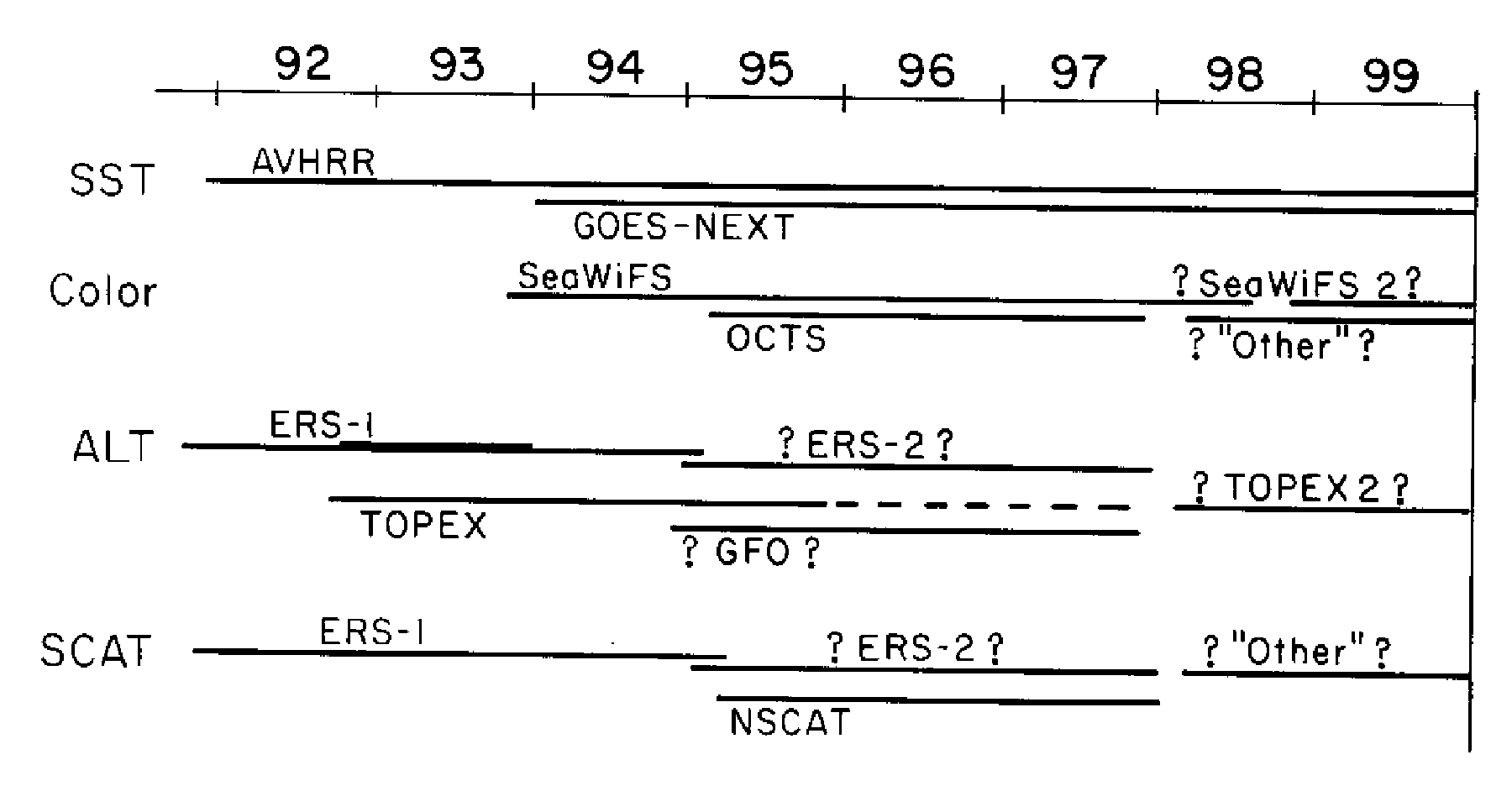
Figure 4. Time line of possible satellite sensor coverage through the 1990s.
The AVHRR sensors carried on the NOAA polar orbiting satellites are presently the primary source of SST data. These measure infrared radiation (IR) in two or three bands, as well as near-IR and visible radiation, which are useful for daytime cloud detection. The use of two or more IR bands allows some correction for atmospheric absorption and scattering. Spatial resolution is approximately l km, and clouds limit the coverage. During periods when two operational satellites are up, it is possible to get four images per day at mid-latitudes, separated by 4-9 hours. Sequences of clear images can also be used to estimate surface velocity via several methods, allowing some estimate of horizontal heat transport, although these methods are still being developed and tested. At present, we expect that the series of polar orbiting satellites with AVHRR sensors will continue through the decade.
The next generation of geostationary satellites (GOES-NEXT) should be operational by the time a field program is carried out. These will have several IR channels and, because they sample every 30 minutes, may be useful in constructing composite maps of SST in regions where clouds are patchy. The spatial resolution will not be as fine as that from the AVHRR, probably in the 4-8-km range. The accuracy is expected to be comparable to the AVHRR, but will need to be tested. Resolution and accuracy at higher latitudes will not be as good.
Ocean temperature can also be sensed by passive microwave sensors, but the footprint of present sensors is too large (hundreds of kilometers) to be of much use in the California Current. Also, the land contaminates such microwave information for hundreds of kilometers offshore, further prohibiting the use of such sensors in this region.
Surface chlorophyll pigment concentrations are estimated from ocean-color sensors, from which estimates of phytoplankton biomass and primary productivity are also possible, although they are still in development. Clouds, fog, and mist interfere with color sensors, as they do with the IR sensors discussed above. Several ocean-color sensors are planned for the future, but the best sensor and only dedicated color mission presently planned and funded will be Sea-WiFS (Sea-Viewing Wide Field Sensor). It is scheduled for launch in the summer of 1993 and designed for a five-year mission. It will sample in eight visible bands, designed to estimate surface chlorophyll concentrations and to separately estimate dissolved organic matter, with approximately 1-km horizontal resolution and continuous onboard calibration. The SeaWiFS sensor will provide complete oceanic daytime coverage every two days (with large regions obscured by clouds), crossing the equator near noon. There are plans for a SeaWiFS follow-on in 1998, under EOS funding, to maintain continuous measurements.
Another instrument, the Japanese ocean color temperature sensor (OCTS), samples the same bands as Sea-WiFS, but with a poorer signal-to-noise ratio and an earlier-morning orbit, resulting in less accuracy. It will launch aboard the Japanese ADEOS satellite, which will also carry the U.S. NSCAT scatterometer, used to estimate the surface vector wind field (see below). The proposed launch date is early 1995, with a nominal three-year mission.
Other color sensors are planned by various groups for the period after 1998, but none are dedicated to ocean color. The oceanographic moderate-resolution imaging spectrometer (MODIS) sensor was designed with a tilting view angle to avoid sunglint (MODIS-T). Budgetary considerations have delayed it from the initial U.S. Earth Observing System payload. The nontilting version (MODIS-N) is still part of the payload. Data from MODIS-N, with a large number of visible, near-IR, and IR bands, will be similar to SeaWiFS, but with improved signal-to-noise characteristics and with the addition of bands to measure chlorophyll fluorescence. Because sunglint will contaminate part of the MODIS-N viewing area, two day global coverage will not be possible until both MODIS-N instruments are in orbit in the year 2000.
The European Space Agency (ESA) plans to launch the medium-resolution imaging spectrometer (MERIS) in 1998 as well. This is also a nontilting instrument. It is a full spectrometer, with 15 programmable bands (in terms of width and placement) that can be downloaded to the ground. MERIS will measure both ocean color and chlorophyll fluorescence wavelengths, in bands similar to MODIS-N but with poorer performance.
Surface geostrophic velocities can be calculated from the slopes of the ocean's surface heights, which are sampled along subsatellite tracks by altimeters. These instruments use microwave radar and are not affected by clouds. Altimeter data will be collected by the European remote sensing satellites, the first of which (ERS-1) was launched successfully in July 1991 with a three-year mission. The U.S. dedicated altimeter mission, TOPEX, will launch in the summer of 1992 with a nominal three-year mission, likely to be extended to five years. TOPEX will have an exact repeat track with a 10-day repeat, resulting in tracks separated by approximately 250 km. Along each track, cross-track geostrophic velocities can be calculated from the slope of the ocean height, but a long-term mean must be removed in order to remove the influence of the geoid, which is not known well enough to be removed in any other way. This also removes the mean velocity, leaving the time-variable signal (seasonal and shorter time scales). Although the ERS-1 satellite will change its orbit a number of times, it will be in an exact repeat orbit with a 35-day repeat period from April 1992 through December 1993.
Thus during mid 1992 through 1993, the combination of ERS-1 and TOPEX altimeters should sample the surface velocity field well enough to document the seasonal evolution of the jet and eddy system in the California Current. If TOPEX continues to function for five years and if an ERS-2 satellite is left in an exact repeat orbit during a year or more of the 1995-98 period, another high-resolution picture of the surface currents will be possible. It is also possible that a Geosat follow-on (GFO) may be launched by the U.S. during 1994, allowing similar overlap with TOPEX and good coverage of the surface velocity field in the 1994-98 period.
Winds are sampled by scatterometers, which are also active microwave instruments, unaffected by clouds. The ERS-1 scatterometer samples a 600-km band on one side of the satellite, covering most of the ocean in approximately three days. The footprint is approximately 50 km wide and cannot be used if any part of it touches land (no wind data from within 50 km of land). The scatterometer shares an antenna with the SAR instrument, therefore it is not operated at all times. The ERS-2 scatterometer will provide similar coverage beginning in 1995. Better coverage will be provided by the NASA scatterometer, which will be launched in early 1995 and will sample most of the ocean in approximately two days. The basic footprint of NSCAT is a 25-km region, although for most purposes it will be averaged into 50-km regions. Thus NSCAT may indicate winds on slightly smaller scales and closer to the coast than the ERS sensors. It is expected that wind fields from any given 2-day or 3-day period (from one sensor) will have relatively large errors (several m/s), but that averages of 10-30 days will be better.
For the above reasons, scatterometer winds will be less useful on time scales of 10 days and less (individual wind events, storms, etc.) and in the region within 50 km of land; they will be more useful for seasonal and interannual scales over the larger-scale California Current system. Measurements at buoys, and operational numerical weather prediction models will remain the primary source of wind data over short time scales and the only source of wind data within 25-50 km of the coast, except possibly for shore-based radar or lidar systems, which are still in the experimental stages. If the operational wind models assimilate the scatterometer winds into their forecasts, the accuracy of the forecast fields may improve significantly, providing a "dynamical interpolation" of the scatterometer winds on short time scales.
NOAA-Fisheries (La Jolla) proposes to carry out a west coast fishery hydrography program, FORAGE, which is designed to relate mesoscale features to survival and recruitment of groundfishes along the central California coast. The study area coincides with the ONR study area, and coordination of research activities with ONR is planned. FORAGE is proposed as part of the NOAA Coastal Oceans, Coastal Fisheries Ecosystem theme. Preliminary cruises are being made by NOAA scientists in support of FORAGE, and in coordination with ONR, but FORAGE is not funded by the Coastal Oceans Program at the present time.
Each year the CalCOFI program sponsors quarterly surveys of 16-20-day duration; six lines (68 stations) south of 35°N are occupied each quarter. The current sampling pattern has been used since 1985, and no plans exist to modify it in the foreseeable future. Although the pattern is smaller than in earlier years, the stations currently occupied each quarter have been consistently occupied for the last 40 years.
Canadian researchers have maintained time series sampling of biological and physical oceanographic conditions off the outer coast of Vancouver Island since 1985 (the La Perouse Program). Sampling lines extend about 100 km from the coast and (routinely) from the mouth of Juan de Fuca Strait to about midway along Vancouver Island. Additional lines to the north are occupied opportunistically. Current meters are moored at 3-4 locations; plankton samples (about 12 per survey) are collected during 5-6 surveys per year; and CTD profiles (about 50 per survey) are taken during about 10 surveys per year. Trawl and acoustic surveys of finfish distribution and stock size take place 2-3 times annually.
Other large-scale U.S. programs, such as the Joint Global Ocean Flux Study (JGOFS) and World Ocean Circulation Experiment (WOCE), are unlikely to contribute substantially to efforts in the California Current system. WOCE has solicited proposals for a mooring in the California Current system. At present, this mooring has a low priority and is not likely to be funded. WOCE line P17 extends offshore from the coast in the vicinity of the EBC survey region (38°N) and will be sampled once in mid 1993. This will provide a line of deep CTD casts to supplement the EBC surveys, which will usually sample only to approximately 200 m, since WOCE researchers use SEASOARs to make rapid, high-resolution surveys and will make only a few deeper CTD casts.
Field work carried out by other agencies and individual investigators from the institutions along the coasts of Mexico, California, Oregon, Washington, and Canada are difficult to inventory or predict with any certainty. Off Baja California, CICESE plans to sample offshore lines on a regular basis in what has been described as a "mini-CalCOFI." It will also equip two offshore islands with modern tide gauges, to estimate variations in transport in the 200 km next to the coast. Other continuing fieldwork includes studies supported by the Minerals Management Service in the Los Angeles Bight and investigations in Monterey Bay conducted by the Monterey Bay Aquarium Research Institute (MBARI); the University of California, Santa Cruz; Moss Landing Marine Laboratory, and the Naval Postgraduate School. NOAA-Fisheries, Tiburon Laboratory, conducts an annual survey for pelagic juvenile rockfish over the shelf off San Francisco, and every three years the Alaska Fisheries Science Center conducts a trawl survey along the shelf from the Canadian border to Point Conception.
Finally, an interdisciplinary group of coastal ocean scientists has joined together to form CoOP (Coastal Ocean Processes). The goal of this group, as stated in the Draft CoOP Science Plan (dated 11 February 1992), is "to obtain a new level of quantitative understanding of the processes that dominate the transports, transformations and fates of biologically, chemically and geologically important matter on the continental margins." The spatial domain of interest to this group extends from near shore to the continental shelf, slope, and rise.
Although still in its formative stages, the CoOP organization envisions field studies that would be initiated by a group of scientists who organize a workshop to define specific interdisciplinary objectives and the approaches needed to accomplish those objectives. In concert with the CoOP steering committee, the plan will be refined and distributed. Ultimately, proposals to accomplish the objectives would be solicited from the community at large. Since GLOBEC and CoOP share common interests in the transport and transformation of nutrients and biomass, those involved in the GLOBEC program should be aware of possibilities for synergism. As a hypothetical example, one could imagine a larger-scale GLOBEC program providing the spatial and temporal context for specific CoOP process studies with a focus over the shelf and/or nearshore zone.
The Peru Current off central and southern Chile is potentially most similar to the California Current. The West Wind Drift in each hemisphere flows toward the east between 40 and 50 degrees and feeds into the equatorward surface current. A poleward undercurrent is often found over the shelf break in both systems. There is strong input of fresh water from the Columbia River (46°N) off North America and from heavy precipitation and coastal runoff south of 40°S off South America. The winds have a seasonal cycle which is greatest (including a reversal in alongshore direction) at latitudes of approximately 35°-40° in both systems. Satellite images show the presence of convoluted fronts in surface temperature and color, although the currents associated with those structures in the Peru Current have not yet been measured. Interannual variability has been shown to be strongly connected to ENSO events in the California Current, through both oceanic and atmospheric paths. This connection may be even stronger off South America, where the equator directly intersects the continent.
Eastern boundary current fishery recruitment studies on sardines and anchovy (SARP) have been proposed, and some work has been carried out under the Ocean Science in Relation to Living Resources (OSLR) Program of the Intergovernmental Oceanographic Commission (IOC) and the Food and Agriculture Organization (FAO). These studies did not progress to a point that would enable an extensive comparison of the systems, but they demonstrated that the comparative method was fruitful. SARP also provides a ready-made infrastructure for international GLOBEC to exploit and create a comparative eastern boundary current study.
In December of 1991, the North Pacific Marine Science Organization, PICES, held a workshop attended by scientific delegations from the United States, Canada, China, Russia, and Japan. One of the charges of the workshop was to identify key marine research problems and areas for cooperative research programs. Many of the PICES workshop recommendations are similar to those of the current GLOBEC report. For example, PICES recommended international studies of long-time-scale climate variability and species changes preserved in the varved sediments of the basins of the North Pacific, a recommendation of the current workshop. Clearly, an expansion of the work proposed here to an international boundary current program on climate change would be highly beneficial.